


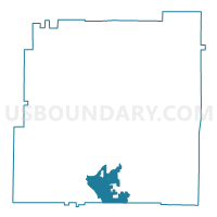
01518 - WOODLAND HIGH Voting District, Bartow County, Georgia
About
Outline

Summary
| Unique Area Identifier | 560301 |
| Name | 01518 - WOODLAND HIGH Voting District |
| County | Bartow County |
| State | Georgia |
| Area (square miles) | 10.77 |
| Land Area (square miles) | 10.65 |
| Water Area (square miles) | 0.12 |
| % of Land Area | 98.89 |
| % of Water Area | 1.11 |
| Latitude of the Internal Point | 34.10628230 |
| Longtitude of the Internal Point | -84.84561360 |
Maps

Graphs
Select a template below for downloading or customizing gragh for 01518 - WOODLAND HIGH Voting District, Bartow County, Georgia


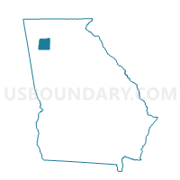
Neighbors
Neighoring Voting District (by Name) Neighboring Voting District on the Map
- 01504 - CARTERSVILLE WEST Voting District, Bartow County, GA
- 01507 - EMERSON Voting District, Bartow County, GA
- 01511 - MISSION ROAD Voting District, Bartow County, GA
- 01514 - TAYLORSVILLE Voting District, Bartow County, GA
- 22310 - MCCLURE MIDDLE Voting District, Paulding County, GA
Top 10 Neighboring County Subdivision (by Population) Neighboring County Subdivision on the Map
- Cartersville CCD, Bartow County, GA (51,048)
- North Paulding CCD, Paulding County, GA (35,071)
- Emerson CCD, Bartow County, GA (12,044)
- Euharlee-Taylorsville CCD, Bartow County, GA (8,415)
Top 10 Neighboring Place (by Population) Neighboring Place on the Map
Top 10 Neighboring Unified School District (by Population) Neighboring Unified School District on the Map
- Paulding County School District, GA (142,324)
- Bartow County School District, GA (80,433)
- Cartersville City School District, GA (19,724)
Top 10 Neighboring State Legislative District Lower Chamber (by Population) Neighboring State Legislative District Lower Chamber on the Map
- State House District 17, GA (79,395)
- State House District 15, GA (58,888)
- State House District 14, GA (58,382)
Top 10 Neighboring State Legislative District Upper Chamber (by Population) Neighboring State Legislative District Upper Chamber on the Map
Top 10 Neighboring 111th Congressional District (by Population) Neighboring 111th Congressional District on the Map
Top 10 Neighboring Census Tract (by Population) Neighboring Census Tract on the Map
- Census Tract 1201.01, Paulding County, GA (12,406)
- Census Tract 9606, Bartow County, GA (8,969)
- Census Tract 9610, Bartow County, GA (8,415)
- Census Tract 9608.03, Bartow County, GA (5,149)
- Census Tract 9609.01, Bartow County, GA (2,839)
- Census Tract 1201.04, Paulding County, GA (2,827)